
Google Maps is getting clearer satellite images and enhanced Street View content, while Google Earth will soon feature a vast collection of historical imagery. All of these improvements are powered by Google’s advanced AI technology.
According to the Google blog, starting this week, the company will roll out sharper satellite images on both Google Maps and Google Earth. This is made possible through their Cloud Score+ AI model, which can detect and remove clouds, cloud shadows, fog, and other visual obstructions. Importantly, this AI update does not interfere with real-world features like ice, snow, or mountain shadows, preserving their natural look.
With Cloud Score+, Google aims to provide users with a “brighter and more vibrant globe” and a “clearer, more detailed view of the Earth”. An example image below shows the enhanced look of Egypt’s Toshka Lakes using this new AI technology.
Google Street View Expands to More Countries
At the same time, Google is rolling out one of its largest Street View updates, introducing new images from around 80 countries.
Street View Now Available in New Countries
This Street View update will first roll out in Bosnia, Namibia, Liechtenstein, and Paraguay. Users will also see extensive new images in countries like:
- Australia
- Argentina
- Brazil
- Costa Rica
- Denmark
- France
- Iceland
- Japan
- Mexico
- New Zealand
- Philippines
- Rwanda
- Serbia
- Spain
- South Africa
- Switzerland
- Uruguay
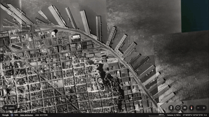
Google Earth Introduces 80 Years of Historical Imagery
Starting today, Google Earth will feature historical satellite and aerial images spanning up to 80 years. These historical images can be accessed through both the web and mobile versions of Google Earth.
In a recent video, Google shared a black-and-white photo of San Francisco taken by pilots from Oakland Airport in 1938. The image offers a glimpse of how the city’s ports were mainly used for transportation and industrial purposes back then. When compared to images from 2022, users will now see modern piers, bustling restaurants, and docked cruise ships in the harbor.